SAM IS ....
Orthomosaic Maps for Construction Sites explained by Carrot Drone Services

Drones are fast becoming an important asset in the construction and building industry. Using orthomosaic maps significant time and money can be saved on all sizes of projects. This article will explain what an orthomosaic map is, what it can be used for and the advantages of using drones to create orthomosaic maps for your project.

Credit to Carrot Drone Services

What is an Orthomosaic Map?

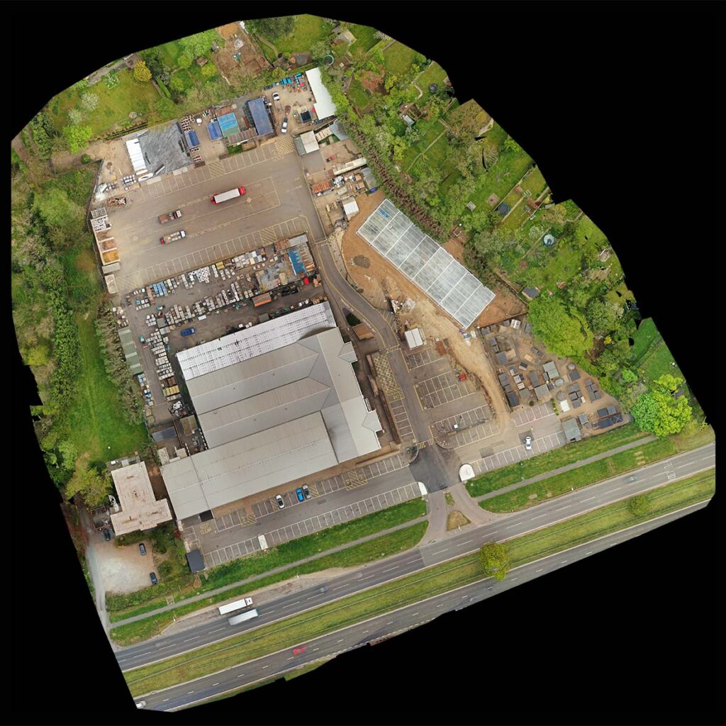
An orthomosaic map perfectly represents an area of land, it is an accurate representation of the geography of the area. They are a bit like satellite images, such as Google Earth, but unlike satellite images the data is totally up to date, the physical representation is far more accurate and the quality is significantly superior.

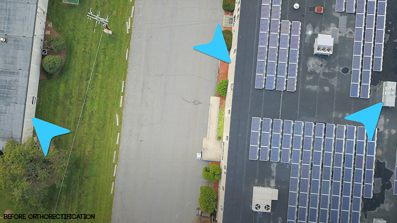
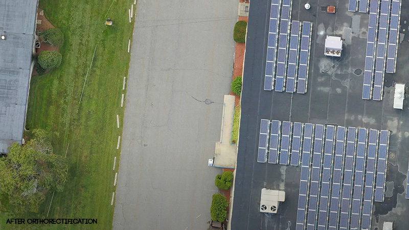
The orthomosaic map is created by piecing together hundreds if not thousands of separate, but overlapping, photos (orthophotos) taken by drone. Using GPS data that the drone tags each picture with the photographs are then orthorectified to create a geometrically accurate picture of the land.

Normal aerial photos have a perspective view, an orthorectified image is geometrically accurate creating a perfectly straight down view. Orthomosaic maps have no distortion and are to a uniform scale.

The orthorectification process corrects for:

  • Lens distortions
  • Camera tilt
  • Perspective
  • Topographical relief
  • Elevation
Before Orthorectification
After Orthorectification

Orthomosaic maps can be produced quickly, easily and cheaply allowing imaging to be carried out more regularly. Some projects even requiring imaging to be done on a daily basis.

The costs of using a drone operator to create an orthomosaic map are negligible compared to the cost of even the smallest project, especially bearing in mind the savings that up to date data can provide all involved.

Uses of Orthomosaic Maps in Construction

An orthomosaic map allows for accurate measurements to be made of the land and can be used to streamline every stage of a construction project.

Orthomosaic maps can help project teams with:

  • Documenting project progression
  • Improving communication with all agencies involved
  • Dynamic & timely decision making
  • Keeping clients informed of progress
  • Fast & safe site inspections
  • Locating areas of workflow that can be improved & streamlined
  • Observation of hinderences/stoppage
  • Checking conformance to schedule
  • Assessment of quality of work
  • Assessment of stored supplies
  • Asset monitoring
  • Resolving scheduling issues with staff and supplies which may have occurred due to lack of up to date information
  • Dispute resolution
  • Evaluating compliance with appropriate regulations
  • Topographical surveys
  • Locating drainage spots
  • Studying vegetation
  • Studying water ways
  • Optimising grading & earthwork plans
  • Comparing differences from “as built” to the original plans

CAD drawings can be overlayed to check for errors and that drainage and utilities are located correctly.

Drone maps are routinely being used to monitor projects, to keep records and document progress.

Advantages of Orthomosaic Maps

Drone surveying of a site is time-saving, thorough, reliable, clear and can be done inexpensively on a regular basis to ensure the most up to date data is being used.

Traditional methods of site monitoring involved boots on the ground which was inaccurate, incomplete (not all areas being accessible), time consuming and not very regular. Once the survery had been completed the situation would have changed significantly.

Improved Communications

With numerous agencies, from architects, clients, investors, contractors, banks to workers, being involved in construction projects data can be shared quickly and easily. Disparate stakeholders are able to be kept up to date especially when project meetings are taking place virtually. The resultant maps are normally cloud based so easily shared amongst all interested parties.

Quicker & Improved Decision Making

With up to date and accurate information from drone mapping project managers can make quicker and more strategic decisions avoiding costly mistakes, saving time and money and keeping the project on track.

Safety

Aerial mapping is helping contractors spot and assess safety risks and potential hazards where in the past these have been spotted too late avoiding injury and expensive litigation.

Dispute Resolution

As the orthomosaic map represents a complete and up to date picture of the site disputes can be easily resolved or, preferably, avoided. With drone mapping being used to keep documents it is much harder for any parties to dispute issues down the line. Drone maps are increasingly being used in courts to resolve legal cases.

Save Time & Money

Ultimately the use of inexpensive, safe and accurate orthomosaic drone mapping will save time and money allowing all agencies to then concentrate on new profit making projects.

Contractors using drones are able to stay ahead of the competition, winning more clients and maximising profits.

Conclusion

This article explains that if you are in the building/construction industry why you should be considering the regular use of drones in your projects and how they can offer an almost immediate return on investment.

Carrot Drone Services are experienced drone operators having held CAA approval since 2015 and are fully insured.

Please contact us now to discuss how we can help you improve efficiency and drive down costs of your projects. We will carry out your first drone orthomosaic map for free.

Please note that orthomosaic maps are not guaranteed to have survey grade levels of accuracy.

Contact: Carrot Drone Services

Read further articles on:

15 March 2025

SAM IS ....
DroneX Announces ARPAS-UK as Headline Partner for 2021

ARPAS-UK, the not for profit Trade Association for the UK Drone Industry, has been announced as a headline partner for this year’s DroneX Tradeshow & Conference.

ARPAS-UK – dedicated to supporting members of the UK drone community – will be joining DroneX this year on the 5th & 6th October at the ExCeL London.

Being the only trade association for the UK drone community, ARPAS work on behalf of their members to support businesses and ensure safe operational best practice among drone users.

They have been recognised by the Counter Terror Awards for their efforts surrounding counter terror strategy in the UK and overseas, and sponsored one of the award categories in 2019 – the UAV Product Award. This award recognises the most innovative products developed for the purpose of protection against hostile drones. This is just one example of the ways in which ARPAS-UK support start-up businesses, larger established operations, and everything in between through promoting innovation and best practice.

The DroneX Tradeshow & Conference is delighted to have ARPAS-UK on board as a headline partner this year, promoting safe and regulatory use of drones which are transforming the processes of many sectors and improving safety.The possibilities of unmanned vertical flight are endless and ARPAS-UK play a huge role in the progression and growth of businesses within the UAV industry.

Adnan Hiroli, the Event Director of the DroneX Tradeshow & Conference, said “We are so excited to be bringing you this incredible new show this year with the support of our headline partners, ARPAS-UK and Drone Major. It is so important for members within the UAV industry to have the support and guidance they need which will allow them to grow their business and encourage best practice. Unmanned vertical flight is ever growing and developing, creating unparalleled opportunities for businesses. We can’t wait for you to see what we have in store for you at the show this year.”

DroneX will allow you to take a firsthand look into the latest technological advancements, with more and more companies incorporating drones for different purposes, this is an unmissable event.

Register for your free tickets now to see ARPAS-UK at the show on the 5th & 6th October, alongside 300 exhibitors, 100 seminars and an incredible schedule of keynote speakers. To find out more about the show and plan ahead in order to make the most of the two days, visit dronexpo.co.uk.

SAM IS ....
A Brave New Dawn in the world of Engineering with the Advent of Drone Technology

Engineers aren’t known for taking risks lightly – what we do doesn’t really allow for error and taking a risk brings in too much scope for error. And if engineers are slightly cautious, engineer surveyors are even more so.

But being in a traditional, perhaps even cautious sector, doesn’t mean that we aren’t always looking for new ways to solve old problems. And increasingly, those new ways are tech-based. One of the most exciting applications of new technology I have encountered is drones.

Andy Kidd Chief Engineer at British Engineering Services Ltd

Clear Regulations

Safety always has, and always will be, paramount when it comes to engineering – not just at the design and build stage but throughout the lifetime of the equipment. Which is why there are very firm and clear regulations around the inspection and upkeep of equipment such as cranes and other lifting equipment.

Periodic, thorough examinations of lifting equipment must be completed every six or twelve months unless a risk-based examination scheme is in place. But for most, this regular and necessary examination requirement can mean undertaking a lengthy and expensive process, usually involving MEWPs (Mobile Elevating Working Platform) or erecting scaffolding every single time.

Which is fine because it’s necessary, but I said, we are always looking for new ways to solve old problems and drones have shown themselves to have an important and cost-effective role to play in equipment examinations.

We have been exploring the potential role for drones for some time, but it is a conservative sector, so it took a while before a client willing to try them appeared. In 2016, that innovator presented themselves and asked us to explore the use of drones to examine their crane equipment.

Reducing Risk, Cost and Time

Their motivation was not only to save time and cost but to reduce the risk of working at height in completing the examination. So, sending a drone up to do the job seemed like the best option. And it was – the client was able to have the examination completed within hours rather than days and at a fraction of the cost. The future for drones in engineering examinations had just been opened up.

But before engineers run towards drones en masse to solve their examination problems, there are limitations to what drones can do. A thorough examination requires all our senses of which drones can only (currently) replicate one – vision. But even having that one sense digitised can bring huge benefits.

One recent example is where I had to examine a number of runway tracks and overhead cranes for a company – trouble was, they were incredibly awkward to access.

Traditional Access Methods

We looked at other options such as a cherry picker but even that wouldn’t provide the necessary access and the hope was that we could avoid the cost and delay of bringing in scaffolding. Thankfully, during the initial accessed examination, nuts and bolts were marked with contrasting paint to help identify any movement in the structure. Something that a drone-mounted camera could monitor with ease and impressive precision.

The realisation that the drone could help manage this aspect of the examination, led us to investigate how they could reduce the need for annual, hands-on examinations. In the end, were able to develop an examination scheme that used drones on an annual basis to check for movement with the full, accessed examination taking place every three years.

Significant Savings

The savings made by removing the cost of scaffolding in two out of every three years is significant. And if no deterioration is noted during the three-year cycle, we believe we can extend the period between accessed examinations and all the cost that entails, to five years.

That is significant whichever metric you are using to measure effectiveness, but it is only scratching the surface of how drones can assist examinations. And while the applications may be somewhat limited today, I have every confidence that drones will play an increasingly significant role in engineering examinations as the tech develops and as engineers see just what they are capable of.

Andy Kidd is Chief Engineer at British Engineering Services

Interview by Iprosurv, an ARPAS-UK Member

22 April 2021