SAM IS ....
UAV LiDAR improves land mine clearance planning

Pedro Pacheco is a GIS Officer and Drone Pilot at The HALO Trust in Angola. Pedro has been working with Routescene, an ARPAS-UK member, since 2021 flying UAV LiDAR missions across minefield sites to inform mine clearance planning. This article explains the work Pedro undertakes, it describes the conditions he and the drone team operate in, the equipment they use and the challenges they face.

Q. What drone are you using for this work?
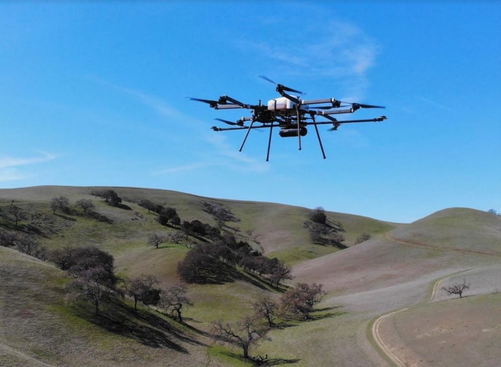
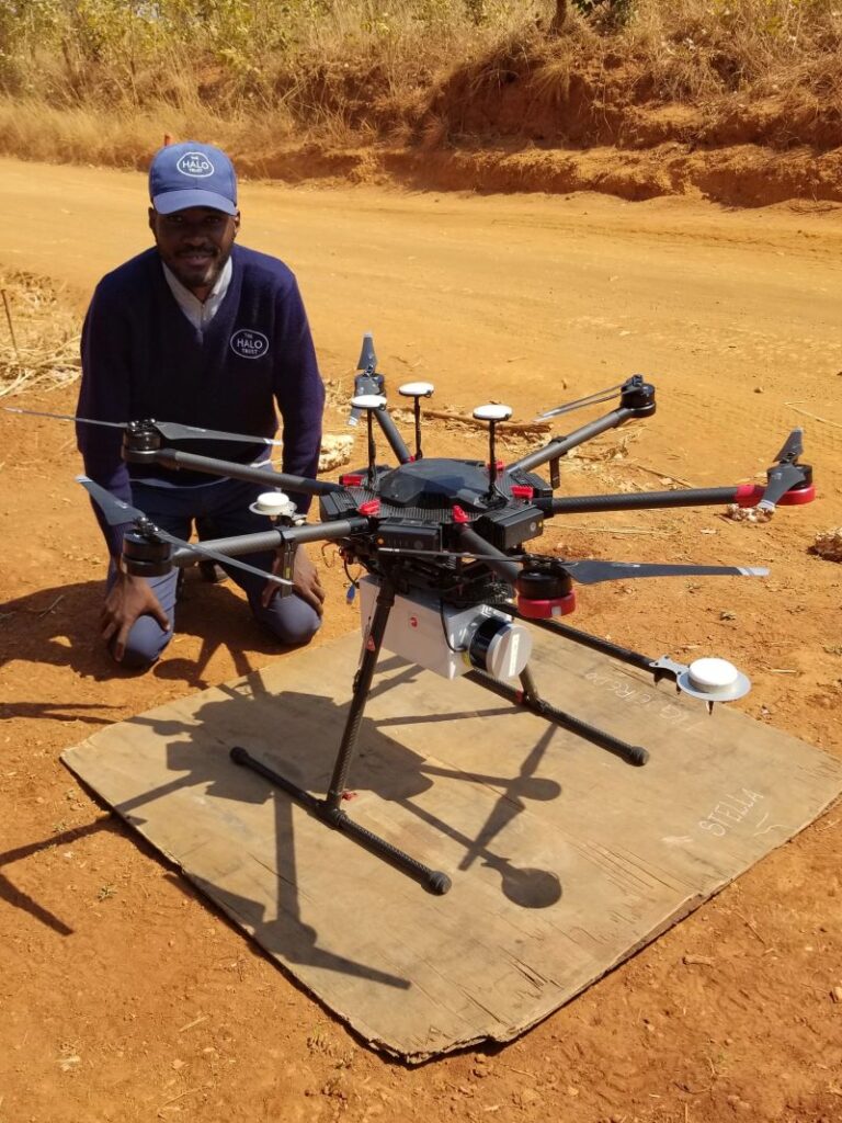
A. We are using a DJI M600 Pro, which is a hexacopter capable of lifting a 5kg payload for approximately five minutes, and automated flights are executed using the DJI Pilot Application.

Q. What UAV LiDAR system are you using?
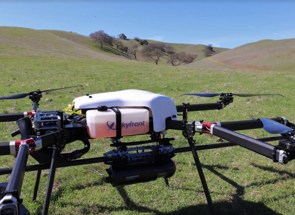
A. We are using a Routescene UAV LiDAR System. The unit contains a 16 channel LiDAR sensor, capable of collecting approximately 600,000 points per second, a GNSS/INS sensor and data storage to capture 12 hours of data. The system was designed to be resistant to in-flight vibrations and handling by users. t doesn’t require a mobile or internet connection to operate which provides us with operational autonomy and data security. GNSS data is collected for the post processing of the trajectory to ensure the data is as accurate as possible.

Q. Describe a typical day for us.
A. Work usually starts the day before the field surveys take place. This day focuses on planning and includes charging batteries, checking equipment and preparing the flight plans and risk assessments.
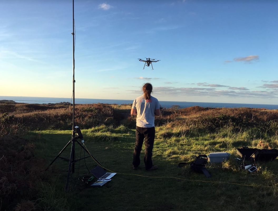
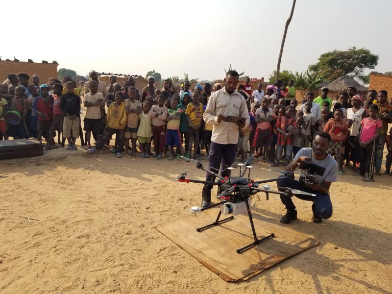
The drone team heads to the field survey site in a Kamaz down sandy roads. Depending on the location and the condition of the roads this journey may take 1-2 hours for many missions or up to 12 hours if taking the sandy roads down to Mavinga. In the field a suitable location is identified for setting up the drone, the UAV LiDAR system and the base station. The missions are flown and the data is downloaded and processed once back in the office.
When a survey mission is in a more remote location and will take more than one day to complete, the team will stay in one of HALO’s remote demining camps. These camps are built in safe areas that have already been demined and offer safe access to our clearance tasks. These camps are made up of large tents for the deminers and drone team to sleep in.

Q. What have been your biggest challenges as a Drone Pilot whilst undertaking these UAV LiDAR surveys?

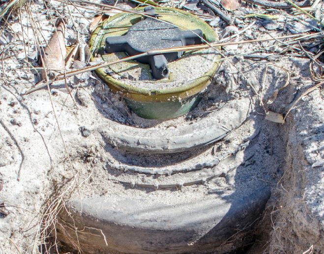
A. We have faced many challenges during data collection. Whilst undertaking missions the most dangerous challenge has been the uncleared land which poses a threat to life to the drone team. This can drastically reduce the choice of suitable drone take-off and landing sites and locations to site the base station. Once we had to use the cleared narrow sandy road for both drone take-off and landing sites and to site the base station, having to move the equipment to let vehicles past.

Limited access to power to recharge batteries during missions is constantly a problem. We have to recharge batteries each evening at the camp. Of course, this can limit the number of flights we can complete in a day, typically 2 per day. Occasional power cuts can lead to further issues with charging between flights. Additionally, the teams are often working in regions that do not have mobile coverage.

Q. What distances are you covering to complete missions?

A. Many of the minefield sites in Angola are 20-30km long and the maximum distance thatthe DJI M600 Pro can fly is 1-1.5km. The travel to site from camp each day can take 2 hourson average due to the terrain and conditions, which also limits the number of missions wecan complete.

Q. How many drone LiDAR surveys have you performed to date?
A. We have completed over 40 missions to date. The number of missions we can manage in one month varies according to the local seasonal conditions. Currently we are undertaking about 6 missions per month. However, this is likely to decrease between October and May due to the Angolan wet season. The optimal time of year for surveys is between May and September when weather and road conditions are best.

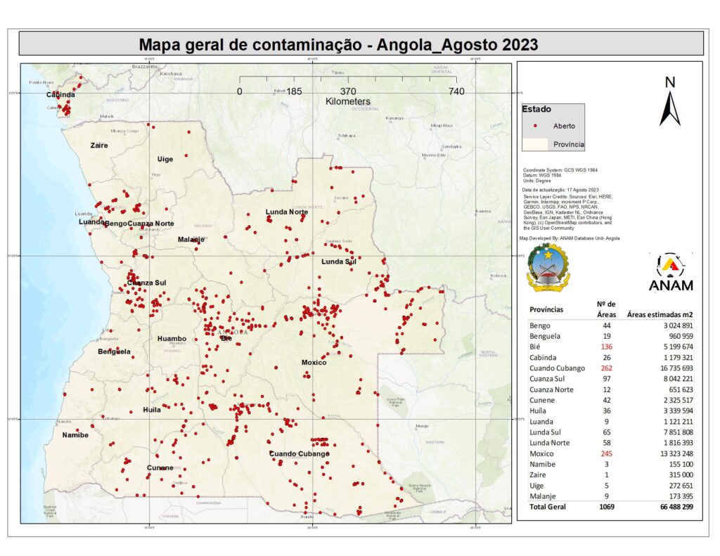
Q. How much mine clearance work is still left to do in Angola?
A. Currently there are 1069 known minefields across Angola, totalling an area of 66,488,299m 2 . The map below provided by ANAM (Angolan Mine Action Authority) shows the scale and location of the known minefields in Angola. The Government of Angola’s aim was to clear the country by 2025, but even with additional resources and scaling up of demining operations there are still many years of clearance ahead.

Q. How have you analysed the data you have collected?
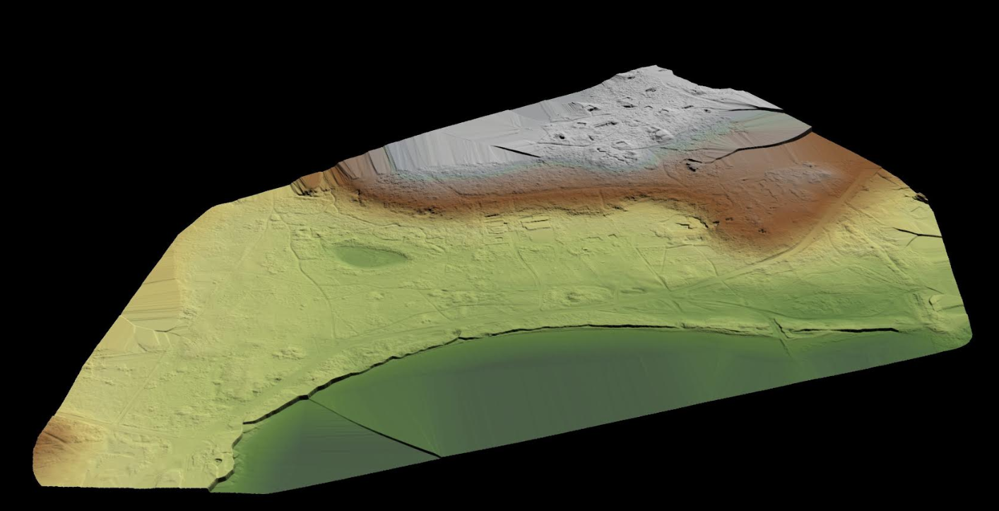
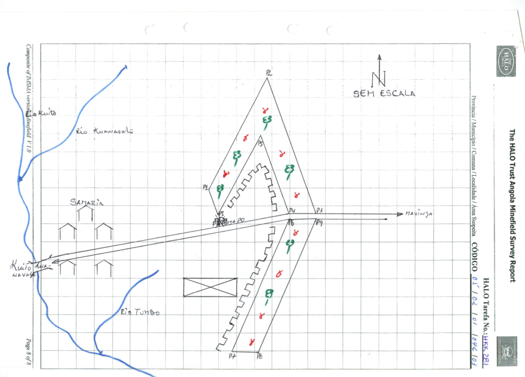
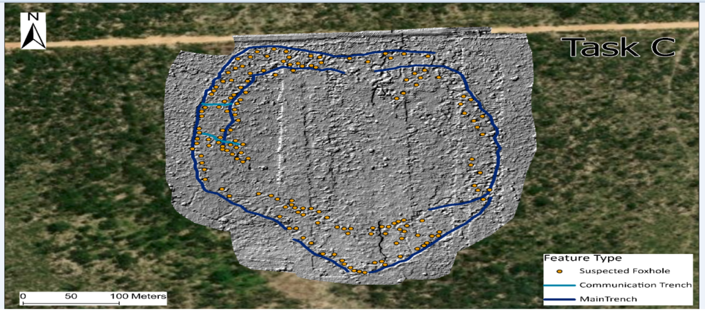
A. We use a specially designed LiDAR post-processing software application, LidarViewer Pro created by Routescene, which we use to clean and process the data. The outputs are Raster files and we load these geotiffs into ESRI’s ArcGIS, then visually inspect the files to identify the location of battlefield features such as trenches, foxholes, shell scrapes and craters, which are indicators of minelaying. We manually annotate the files and produce pdf maps to aid the operations team with the creation of clearance plans.

Q. What has been the impact of this work?
A. UAV mounted LiDAR has had a huge impact on HALO’s mine clearance work in Angola. This technology has provided us with invaluable information about minefields while we clear them or even before we start doing so. The resulting Digital Terrain Models (DTMs) have helped us to understand the terrain and identify the exact locations of potential hazards, which we would otherwise only have limited insight into. This includes the identification of previously unknown trenches, craters and bunkers, which all could indicate the potential presence of minefields. This information is then incorporated into our existing survey methods and the contextual knowledge of our experienced teams on the ground, who feed this into their planning and clearance operations.
On one minefield in Cuito Cuanavale in southeastern Angola we were working for several months to clear a long line of anti-vehicle mines until we believed we had reached the end of it. However, the UAV LiDAR imagery showed several craters from mines in an area far beyond our site which had been detonated because of nearby wildfires. The mine line had in fact continued but in a different direction we were not aware of. Had it not been for the UAV LiDAR results we would not have known about these craters and would have spent weeks or even months scouring the area for the remaining mines. Instead, our deminers could directly clear towards the craters to ensure the area was safe. This is one of countless other examples where this technology has allowed HALO to better target its’ precious resources to protect mine-affected communities and wildlife, and make this land safe for agriculture, access, development and conservation.

Q. How are you received when you travel around the local villages to survey the land?
A. HALO has operated in Angola since 1994 and as a result we have deep roots in the local communities where we have been working and recruiting from for many years. When we go out with a drone and the UAV LiDAR equipment to areas where there is a village we often gather interest, especially from children. In some instances the local community provides us with information that can be useful for targeting the team’s drone surveys.

Q. Tell us about other dangers you face in addition to UXO?
A. Other than UXO, we face very few dangers during our flights. The biggest issue we have faced so far is wildlife interference during a flight. This occurred whilst using a Mavic 2 Pro in a forested region… an eagle swooped down on to the drone while the drone was hovering before landing. We expect the bird thought the drone was a small bird that it could prey on.

Read the case study:

About the authors:

Pedro Pacheco
GIS Officer and Drone Pilot, The HALO Trust
Pedro Pacheco is a GIS officer and drone pilot with The HALO Trust program in Angola. He focuses on the use of drone surveys for non-technical survey support to aid in clearance planning. Pedro graduated from Agostinho University with a bachelor’s in geography, with a focus on Satellite Image Processing and Geospatial Information Technology.

Emma Thomas
Director and Chief Marketing, Sales and HR Officer, Routescene
An experienced marketing specialist, Emma drives the commercial and strategic direction of the business. Utilizing over 30 years of business experience, Emma has cultivated a strong, recognisable Routescene brand, delivering marketing and business development activity to enter new markets, to expand product portfolios and to consolidate existing business.

17 November 2023

SAM IS ....
Improve the efficiency of UAV LiDAR surveys with longer flight times

Small improvements to a drone LiDAR survey can make big differences in efficiency, productivity and safety. A major limiting factor for any UAV survey is the drone’s battery life which, along with the weight of the payload, impacts on the drone’s flight time. Imagine the improved productivity and scope of work which could be undertaken if the drone’s flight time could be significantly increased.

Skyfront and Routescene explored the impact on productivity of using the longest endurance gasoline-electric hybrid multicopter drone, the Skyfront Perimeter 8.

The impact of reducing downtime

Typically a drone utilising lithium polymer batteries, such as a DJI M600, and carrying a 3.3kg payload (for example a Routescene UAV LiDAR system) would operate with a flight time of around 15-20 minutes. Landing, replacing the batteries and take-off between each flight can take longer than the flight itself, directly influencing the size of the survey area that can be flown each day.

To compound this, larger survey sites may require multiple take-off and landing sites, which means all the equipment needs to be moved from one site to the next, further limiting the number of flights in a day. The Skyfront and Routescene teams knew that increasing flight times, thereby reducing the unproductive time in a survey day, could significantly impact on data collection productivity.

The teams tested the Skyfront Perimeter 8 drone carrying a Routescene UAV LiDAR system at the Skyfront headquarters in Menlo Park, California, USA. The Skyfront Perimeter 8 is an eight rotor hybrid UAV designed for carrying heavier payloads such as LiDAR. The Perimeter 8 has both rotor and complete engine redundancy for safety. The results: the Perimeter 8 drone was able to fly for a total of three hours carrying the Routescene payload.

Gert Riemersma, Founder and CTO of Routescene, commented, “Through this testing the team found the greatest benefit gained was regarding efficiency. Due to the longer flight times, only one take-off and landing site was required, removing the need to travel between sites to repeatedly set up. In addition, a considerable amount of time was saved simply by eradicating turn-around times to replace batteries. We estimated that by achieving 3 hours of flight time at 5m/s you can readily cover 54 survey line kilometres, or just over 500 acres. This is equivalent to roughly 10 x M600 flights, which would normally take two days to complete. An impressive result, reducing two days of surveying into less than one day, simply by eliminating downtime.

The Routescene UAV LiDAR system has been designed to maximise productivity, with a solid state disc onboard capable of storing over 13 hours worth of data, more than enough for a full day in the field. The quality of the data being collected is monitored in real-time during the entire drone survey using Routescene’s QA Monitor, a web based app, to make sure you leave the survey site with the data you need. At the end of the survey the data can be downloaded and checked in the field using Routescene’s LidarViewer Pro data processing software.

Gert added, “Routescene has a strong ethos of quality assurance and quality control (QA/QC). Implementing rigorous QA/QC improves data quality and efficiencies. QA Monitor gives you confidence in the data you are collecting while you are collecting it. The last thing you want after completing a long survey flight is to realise there was an issue and the team has to mobilise to fly the area again. It prevents time being wasted, you can identify an issue immediately, remedy it there and then in the field, bringing further efficiencies to the increased gains brought by longer flight times.”

The significance of longer flight times

Longer flight times have a positive impact on safety too. The riskiest parts of a UAV flight are the take-offs and landings, when the drone is under manual control and hence when accidents are most likely to occur. Reducing the number of take-offs and landings obviously directly reduces the probability of an accident.

Brian Maxwell, VP of Business Development at Skyfront, confirmed, “Our flight time of 3 hours was particularly impressive and allowed a huge volume of 3D data to be collected efficiently. We found that we could considerably improve the resilience, efficiency and safety of UAV LiDAR surveys by increasing the flight time.”

Christian Andresen from the University of Wisconsin added, “In 2017 and 2018 we surveyed areas of the Arctic as part of the NGEE Arctic project researching changes to permafrost and ecosystem structure. What we observed over the 2 years whilst working there was how much drone technology improved and the positive impact that had on flight times. The Arctic location was exceptionally remote and all incremental improvements make a huge difference to our efficiency and reduce time spent in the field. A drone that could fly for 3 hours would make a dramatic difference for our future surveys in this remote area.”

For more information on the Skyfront Perimeter 8 drone and Routescene UAV LiDAR system, please visit www.routescene.com and www.skyfront.com.

Video

Footage of the drone in flight with the Routescene LidarPod payload is available at  https://youtu.be/qnxyMHqfDaQ

Photographs

The Routescene UAV LiDAR system mounted under the Skyfront Perimeter 8 drone undergoing endurance testing in California.

Routescene is an ARPAS-UK Member.

Skyfront

11th March 2021

SAM IS ....
Routescene UAV LiDAR system used to reconstruct WWII concentration camp

LiDAR vegetation penetration capability enables concentration camp visualisation

The island of Alderney, a British crown dependency located 10 miles off the coast of France, was once home to a German SS concentration camp. Professor of Conflict Archaeology and Genocide Investigation at Staffordshire University in the UK, Caroline Sturdy Colls travelled with her team to the island to investigate the camp.


Lidar image of the the site with the vegetation removed

The investigation and the surprising results were the subject of a documentary ‘Adolf Island’ produced by the Smithsonian Channel. The documentary showcased Routescene’s 3D mapping technology and demonstrated how LiDAR is currently being used in industries such as archaeology, forensics and heritage to create a bare earth model to identify structures without disturbing or obstructing protected land.


Routescene’s technology uncovers full extent of gravesite

Routescene customer, and frequent collaborator, Flythru, was contacted by Professor Sturdy Colls to conduct a UAV LiDAR survey of the sites at Alderney. Sylt, the concentration camp built and run by the SS, and Longy Common, a graveyard, were chosen based on records from a German War Graves Commission investigation from 1960.


Flythru used Routescene’s integrated UAV LiDAR system. LiDAR is a remote sensing technology which measures the height of the ground surface and other landscape features using laser pulses. Designed for use on drones, Routescene’s LidarPod comprises a carefully selected array of sensors including the Velodyne HDL32 LiDAR scanner. With a scan rate of up to 1.4 million points per second from 32 different lasers angled in a 40-degree field of view, this sensor enables high resolution vegetation penetration. This helps users uncover ground features which are not easily visible from the ground or are obstructed by thick vegetation.


The Routescene LidarPod

Michael May from Flythru commented, “We have been using the Routescene UAV LiDAR system, which includes the LidarPod and LidarViewer, for over 3 years now. For applications where we need to penetrate vegetation it has proved to be a valuable tool. The number of laser hits we achieve on the ground is unparalleled with up to 400pts/m2 through thick vegetation. This equipment is ideal to survey sites which are overgrown  or woods and forests which are inaccessible using conventional survey methods. Without UAV LiDAR it would have taken weeks to survey the Alderney sites. Due to the thick cover of vegetation it would not have been possible to visually detected the structures we found. With Routescene’s system on the UAV we achieved these results in a couple of 15 minute flights.


Speedy data processing

The data gathered was processed on-site immediately after the UAV survey using LidarViewer, Routescene’s 3D processing and visualisation software. Using the Bare Earth Tool within LidarViewer the team quickly and easily removed all the non-ground points to reveal the surface below and produce a Digital Terrain Model (DTM). The DTM exposed previously undiscovered features that had been completely obscured by the vegetation covering the site. The Bare Earth Tool is newly available in the Routescene LidarViewer software package. Designed specifically for heritage applications like this, it considerably reduces the amount of time it takes to digitally remove all features above ground level. This allows artefacts covered by vegetation to be revealed in the DTM.


Michael added, “When you are on-site you need to visually present results as quickly as possible to establish if you have captured the results you need. We had limited time on-site on this project and needed to quickly assess the findings. The data processing with LidarViewer is so quick and easy you can present data within minutes.”

The terrain was covered in thick vegetation

Routescene founder and CEO Gert Riemersma commented, “We are proud the Routescene system is being used for such historically and socially important work. The system has proven to be ideal due to its’ portability and ease of use on such difficult sites. Combined with its’ high level of accuracy, ability to penetrate vegetation and process the data on-site is a real advantage.”


Utilising different survey techniques

In addition to using UAV LiDAR Professor Caroline Sturdy Colls also used photogrammetry, a different remote sensing technique in which hundreds (sometimes thousands) of photographs are taken of a site and stitched together to create an overall three-dimensional model.


Ground Penetrating Radar (GPR), which sends radio waves into the ground and allows artefacts under the ground to be detected, was also used. Overlaying all the results from the three different techniques provided an accurate, highly detailed 3D digital model of the camp, highlighting features of interest both above and below ground for further investigation.


Professor Sturdy Colls said, “The LiDAR and photogrammetry UAV surveys that Flythru completed on Alderney assisted us greatly in our research. The overgrown vegetation and the size of the sites that we were investigating made ground based surveys difficult and using UAV was the obvious choice. Flythru were knowledgeable, competent and friendly and explained every step in the process. Health and safety and securing permissions were at the forefront of their approach. The results were better than we could have hoped for. At SS concentration Camp Sylt many additional structural elements were identified in the LiDAR survey that were previously hidden behind dense vegetation. This allowed us to complete, for the first time, a digital reconstruction of this important site“.


For more information about the Routescene UAV LiDAR system including the software and new Bare Earth tool, please visit www.routescene.com


See the trailer for the documentary including the LiDAR UAV system in action at https://www.smithsonianchannel.com/shows/adolf-island/0/3462210

Both Routescene and FlyThru are ARPAS-UK members.


28th October 2019